Ancient Persian Gulf and its Extent into Iran, Iraq and Kuwait

Ancient Persian Gulf in the 6th Millennium BC: A Text-Based Reading of the Atlas
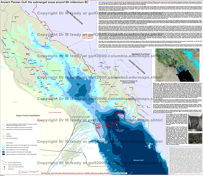
Source title: Ancient Persian Gulf: the submerged areas around 6th millennium BC
Key labels on sheet: Iranian Plateau, Zagros Mountains, Arabian Tectonic Plate/Platform, piedmont foreland plains and hills, marsh/mud flats, alluvial–deltaic deposits, bathymetric intervals.
1) Scope and Frame
The map reconstructs coastlines and shallow basins of the present-day Persian Gulf by highlighting areas submerged around the 6th millennium BC. To the northeast lie the Iranian Plateau and Zagros Mountains; to the southwest, the Arabian tectonic platform. Offshore color bands present bathymetry from very shallow shelves to deeper zones, visually tracking how Holocene sea-level rise inundated the lowlands.
2) Method Notes (as shown on the sheet)
Methodology boxes make clear that the interpretation relies on on-map morphology and bathymetry: coastal profiles, deltaic and alluvial fills, shoals/banks, and sediment patterns. The intent is an accessible reading without off-map sources.
3) Sea-Level Rise and “Drowned Plains”
The legend distinguishes marsh/mud flats, alluvial–deltaic deposits, and arid to semi-arid surfaces. These units indicate where river-borne sediments accumulated across the shallow shelf to form broad drowned plains. Graduated color steps from shore to open water depict progressive deepening and the likely reach of inundation in the 6th millennium BC.
4) Deltas, Low Coasts, and Wetlands
Prominent lowlands—especially along the Tigris–Euphrates delta—carry extensive marsh and mud-flat symbols. These tracts are the most sensitive to sea-level change; circular and semi-circular shallow bands help trace the landward retreat of the shoreline. Large alluvial fans and flats corroborate episodes of shoreline migration preserved in the surface units.
5) Tectonic Setting and Foreland Belts
The piedmont foreland plains and hills along the Zagros front and the broad Arabian Platform to the south structure sediment transport and accommodation. Together they frame a basin dynamic in which deltaic progradation alternates with marine transgression, a rhythm implied by the mapped facies belts.
6) Map-Bound Inferences
-
Ancient shorelines stood further inland. Bathymetric tiers and deltaic/alluvial units show much of today’s gulf floor as shallow to very shallow water ca. 6th millennium BC.
-
Hydrography and sea level act in tandem. River deposition builds seaward while rising seas push the coast back; the map fuses these countervailing forces in one view.
-
Surface facies are key indicators. Marshes, sabkha/mud flats, and banks retain the clearest signatures of late-Holocene shoreline change.
Note: This article is drawn solely from the atlas page—its observation/method boxes and legend—without adding external information.